
While working for the United Nations Resident Coordinator’s office in Timor-Leste, I was asked to put together a virtual library so that all the UN’s publications from Timor-Leste could be accessed online. At the time there was no systematic organization of the UN’s publications in an easy place to find. The virtual library was built … Continue reading UN Virtual Library in Timor-Leste
Category: Projects
Experiments, ideas, strategies, concepts, and plans

Philippe Schneider – Photographer
While working in Timor-Leste, I helped an Australian/French humanitarian photographer to put together a website to showcase his photos from his work around the world. The website was developed using WordPress and was built so the photographer could manage his own photo collections. Originally designed in black, the website was changed in late 2010 to … Continue reading Philippe Schneider – Photographer
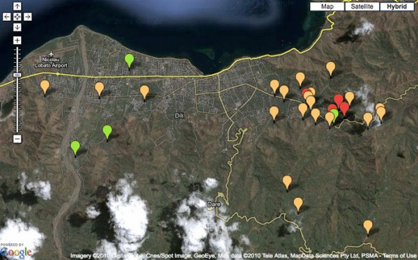
Google Map for Recovery Project Management
As part of a Early Recovery Project for the United Nations Development Programme in Timor-Leste, this interactive map was developed to showcase the possibility of using Google Maps and data from the project to help real-time project management and monitoring. The Google Map uses information entered into a Google spreadsheet to show the projects spatially … Continue reading Google Map for Recovery Project Management
Ho Mapa, Ita Harii Futuru Timor-Leste (#GISDay)
I’m part of the Timor-Leste Geographic Information Group (GIG). For the past few months we’ve been planning to organize an event to raise awareness about mapping and geographic information systems (GIS) work that is going on in Timor-Leste. There isn’t much information about GIS and mapping in Timor. So this event hopes to educate the … Continue reading Ho Mapa, Ita Harii Futuru Timor-Leste (#GISDay)
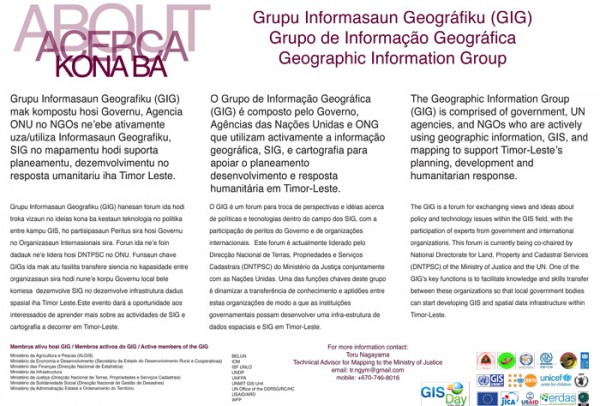
The Geographic Information Group – GIG
This flyer was created during preparations for GIS Day to explain the Geographic Information Group of Timor-Leste. With the help of members in the GIG, the flyer includes descriptions of the group in English, Tetun, and Portuguese. As the GIG became more established by the end of 2009, the GIG met approximately once a month … Continue reading The Geographic Information Group – GIG

Website for The Cluster System in Timor-Leste
This collaborative website was developed for the humanitarian community in Timor-Leste to support their work and information exchange for coordination relief and response operations. One of the main issues from coordinating various United Nations organizations involved in humanitarian relief was understanding what each other were doing to make relief efforts more effective and efficient. This … Continue reading Website for The Cluster System in Timor-Leste

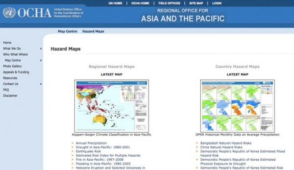
Google Map of Natural Hazard Risk
As part of an ongoing project on mapping hazard risk with the Asia and Pacific Regional Office of the United Nations Office for the Coordination of Humanitarian Affairs (UNOCHA), I helped to develop this interactive Google Map to highlight the risk data the office was collecting and processing. This included hazard risk data developed by … Continue reading Google Map of Natural Hazard Risk
OCHA ROAP Website
Part of my consulting work with the Asia and the Pacfic regional office of the United Nations Office for the Coordination of Humanitarian Affairs was to help to improve their website usability and functionality. Since the basic OCHA website architecture was based on the DotNetNuke content management system, updating the website with the amount of … Continue reading OCHA ROAP Website
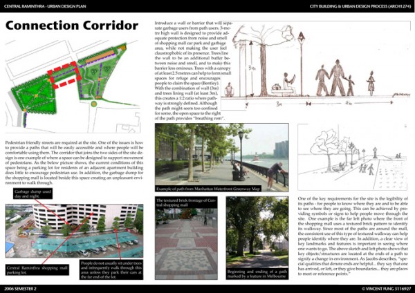
Urban Design Plan
As part of a course on urban design for my Masters programme at RMIT University in Australia, I created the strategy and concept to redesign my neighborhood when I was living in Bangkok, Thailand. The idea was to create a greener and more pedestrian friendly environment. You can download the whole urban design plan here (3.5MB).

How-to Mapping Guide
Working with the United Nations Development Programme on a HIV/AIDs and development programme for Southeast Asia, I researched, wrote, and designed this publication that was released in 2004. This how-to guide stresses the importance of mapping as a tool for understanding and responding to HIV vulnerability. The content for the guide came out of an … Continue reading How-to Mapping Guide