Things are changing and you might not know it even if it’s you who’s actually caused the change. Haven’t figured it out yet? Just look at what you carry everyday and what most people can’t live without these days. I’m talking about your computer, phone and/or tablet. In the last couple of decades we’ve moved … Continue reading Respond or die
Tag: google

Google Earth, Maps, GPS tracks and geotagged photos
Google Earth is an amazing program that brings the world to you. It’s also an amazing tool that also puts you in the driving seat of geography! Not entirely a Geographic Information System (which most normal people don’t need in any case), it does make it easy for you to interpret and “map” your own … Continue reading Google Earth, Maps, GPS tracks and geotagged photos
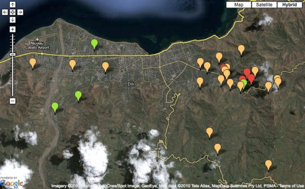
Google Map for Recovery Project Management
As part of a Early Recovery Project for the United Nations Development Programme in Timor-Leste, this interactive map was developed to showcase the possibility of using Google Maps and data from the project to help real-time project management and monitoring. The Google Map uses information entered into a Google spreadsheet to show the projects spatially … Continue reading Google Map for Recovery Project Management

Website for The Cluster System in Timor-Leste
This collaborative website was developed for the humanitarian community in Timor-Leste to support their work and information exchange for coordination relief and response operations. One of the main issues from coordinating various United Nations organizations involved in humanitarian relief was understanding what each other were doing to make relief efforts more effective and efficient. This … Continue reading Website for The Cluster System in Timor-Leste